AJ&K at a Glance 1985-2015 https://pndajk.gov.pk/ajkglances.php?filep=AJKGLANCE/1985-2015
Posts
About AJ&K
The state of Azad Jammu and Kashmir lies between longitude 73° – 75° and latitude 33° – 36° and comprises an area of 5134 square miles (13,297,000 square kilometers). The topography of the area is mainly hilly and mountainous with valleys and stretches of plains. The area is full of natural beauty with thick forest, fast flowing rivers and winding streams. Main rivers are Jehlum, Neelum and Poonch. The climate is sub-tropical highland type with an average yearly rainfall of 130000 mm. The elevation ranges from 360 meters in the south to 6325 meters in the North. According to the 1998 population census, the State of Azad Jammu & Kashmir had a population of 22.973, which estimated to have grown to 33.4 million in 2004. Almost 100% population is Muslim. The Rural to Urban ratio is 88:12.The population density is 258 persons per Sq Km. The literacy rate has increased from 55% to 60% after 1998 census. Infant mortality rate is approximately 56 per 1000 live births, whereas the immuni...
AJ&K at a Glance
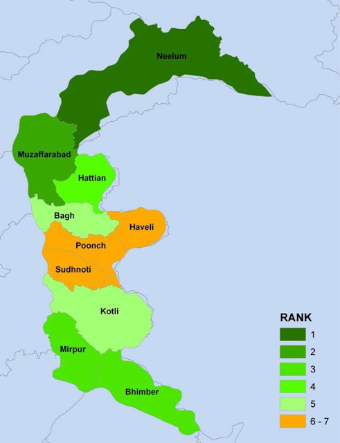
Administrative Divisions The state is administratively divided into 0 3 divisions which are divided into 10 districts . Division District Area (km²) Population (2017 Census) Headquarters Mirpur Mirpur 1,010 456,200 New Mirpur City Kotli 1,862 774,194 Kotli Bhimber 1,516 420,624 Bhimber Muzaffarabad Muzaffarabad 1,642 650,370 Muzaffarabad Jhelum Valley 854 230,529 Jhelum Valley Neelam 3,621 191,251 Athmuqam Poonch Poonch 855 500,571 Rawalakot Haveli 598 152,124 Forward Kahuta Bagh 770 371,919 Bagh Sudhanoti 569 297,584 Palandri AJK Total 10 districts 13,297 4,045,366 Muzaffarabad Description Details Area 13,297 Sq.Km Cultivated Land 13% Villages 1771 Population 4,045,366 Population Growth Rate 2.41% Unemployment Rate per Annum 14.4% Literacy 74% Enrollment rate Primary Boys 98% Enrollment rate Primary Girls 90% Road density 0.64 (km/sq. km) Infant Mortality Rate (per 1000) 58 Population per hospital bed 1309 Popul...
AJ&K History
http://www.ajk.gov.pk/history.php The state of Jammu and Kashmir having an area of 84,471 square miles lies in the North East of Pakistan and North West of India. Russia, China and Afghanistan also shares its border towards the North. Area wise, the State of Jammu and Kashmir was the largest state in the sub-conti nent of Indo-Pak among the 562 princely states of the Sub-continent at the time of its division , and still claims the same status. Its area is almost equal to the total area of Belgium, Denmark, Holland, Austria and Albania, all put together, although it is slightly smaller than Great Britain. The Muslims of Azad Jammu and Kashmir started a liberation against India in 1947. As a result of this war, the Government of Azad Jammu and Kashmir was established on 24th October, 1947, in the liberated area which is about 5,000 square miles out of total area of 84,471 square miles. An area of 28,000 square miles was also liberated by Gilgit Scouts and now it forms Northern A...